Traffic management is an important tool in creating safer and more sustainable communities around the world. Advanced traffic analysis tools need to leverage modern, smart technology in order to create intelligent infrastructure, which will in turn increase efficiency and sustainability, and save lives.
Across the globe traffic deaths are on the rise. In America alone, the National Highway Traffic Safety Administration projects that an estimated 31,720 people died in motor vehicle traffic crashes from January through September 2021. This was an increase of approximately 12 percent from the 28,325 fatalities projected in the first nine months of 2020. The projection is the highest number of fatalities during the first nine months of any year since 2006 and the highest percentage increase during the first nine months in the Fatality Analysis Reporting System’s history.
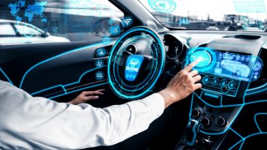
Lidar is a technology that can enhance traffic management systems by creating an accurate real-time 3D representation of roadways for multimodal analysis to design and implement solutions that address infrastructure challenges.
The Power of Lidar
According to the INRIX 2020 Global Traffic Scorecard, in the United States, congestion, often due to inefficiency, cost US$305 billion in 2020. The use of lidar in Intelligent Transportation Systems (ITS) can improve the efficiency of vehicles and reduce traffic through smart infrastructure. This helps to reduce pollution and improve the overall sustainability of the transportation ecosystem.
Understanding which technologies and datasets solve which problems is imperative for any governmental organization looking to begin the community’s infrastructure modernization process. Technologies like lidar and artificial intelligence are being used together for the first time in ITS applications to create intelligent infrastructure systems that inform decision-making and strategy.
Lidar is becoming a key technology in intelligent infrastructure solutions. Unlike older technologies, such as camera, radar and inductive loops, lidar creates a real-time 3D map of roads and intersections, delivering precise traffic monitoring and analytics to detect collisions before they happen.
Lidar reliably collects data in a wide range of lighting or weather conditions, supporting 24/7, 365-days-a-year operation. Additionally, as privacy concerns grow in civic applications, there is a need for non-biased technology. Lidar sensors do not identify biometric data, such as facial features and skin color. This helps preserve community trust and meet privacy law compliance.
A multichannel lidar sensor scans its environment with millions of photons per second, with rotational lidar sensors providing a precise 360-degree view of the surrounding environment. Lidar can detect and classify both moving and static objects. Furthermore, as its own light source, lidar can see in all lighting conditions, including nighttime.
Unlike 2D cameras, lidar sees in 3D, a huge advantage when accuracy and precision are paramount. The laser-based technology produces real-time, high-resolution 3D maps, or point clouds, of the surroundings. Lidar delivers a level of distance accuracy that is superior to cameras, even ones with stereo vision. Whereas cameras make assumptions about an object’s distance, lidar produces and provides exact measurements. Compared to camera systems, lidar’s ability to see by way of precise mathematical measurements decreases the chance of feeding false information to the infrastructure solutions.
Camera performance is also greatly impacted by environmental conditions, such as bright sunlight and glare, and darkness. Cameras are also more susceptible to unpredictable blind spots and generating false positives or negatives. These are issues that do not impact lidar sensors.
Lidar in Intelligent Infrastructure
Municipalities and governments are increasingly recognizing big future potential benefits that can be gained with ITS. Modernization of infrastructure can be advanced by solutions that apply deep learning to transform raw lidar data into actionable road usage and safety information. From movement counts of turning vehicles to analyzing near misses between vehicles, pedestrians and cyclists, a lidar-based monitoring system reliably detects and tracks all road users.
An example of a lidar-based application is Velodyne’s Intelligent Infrastructure Solution, a full-stack hardware plus software system. It combines Velodyne’s lidar sensors and AI software from Bluecity to provide a modern approach to monitor traffic networks. The system is a turnkey solution for traffic operations, transport planning and safety improvements.
Intelligent Infrastructure Solution can predict, diagnose and address road challenges and provide cities with better data for smoothing out traffic problems. Lidar, AI and real-time multimodal analytics provide actionable data, empowering city officials to determine infrastructure needs and initiatives, including roadway planning and optimization, traffic flow, citizen safety, parking management and environmental improvement. The solution provides the ability to improve traffic flow patterns through an intersection, which can reduce congestion and maximize traffic efficiency, in turn decreasing pollution.
Intelligent Infrastructure Solution is helping communities in three continents understand the root causes for traffic safety and operation issues. They can use the data collected to diagnose and then solve the problems uncovered. The solution provides advanced tools to help transportation and city officials plan for and invest in a safer, more sustainable and equitable traffic network, and advance Vision Zero initiatives.
Vision Zero is a global movement to end traffic-related fatalities and serious injuries by taking a systemic approach to road safety. The premise of this strategy is that road deaths and injuries are unacceptable and preventable. First implemented in Sweden in the 1990s, Vision Zero has proved successful across Europe – and now it is gaining momentum in North America, South America and India.
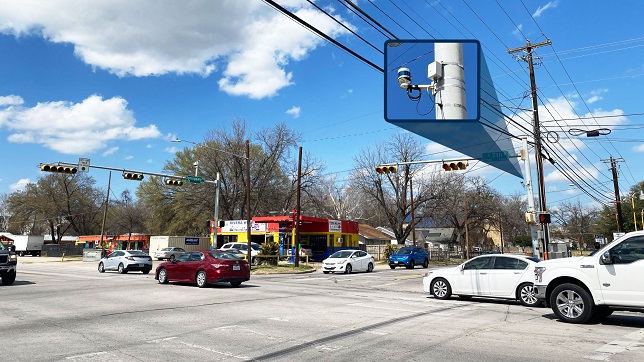
For example, Intelligent Infrastructure Solution is deployed in the city of Austin, Texas USA to help achieve its Vision Zero goal of eliminating traffic deaths and serious injuries on Austin streets. The installation began with a pilot at an intersection that has been identified as needing improvement due to accident history, fatality risks, speeding prevalence and congestion. Austin is testing the solution at this intersection to demonstrate data accuracy and scalability to maximize taxpayers’ dollars.
Intelligent Infrastructure Solution provides a data-driven approach to roadway safety, through Surrogate Safety Analysis of all road users. It enables governments to take a proactive approach on safety by offering real-time Surrogate Safety Analysis of not only vehicles, but also vulnerable road users.
Let’s look at some of the ways a lidar-based intelligent infrastructure solution can be used.
- Safety Analytics. Intelligent infrastructure solutions, using a single lidar sensor, provide near-miss analytics that can be used to predict, diagnose and address road safety challenges before the next collision happens. Today’s camera-based solutions require several cameras per intersection or identified public area, which typically take longer processing times to get the final analysis. Traffic studies aren’t complete if they operate only at certain hours or under certain conditions.
- Traffic Efficiency and Sustainability. These solutions deliver reliable real-time traffic data to optimize traffic light timing based on congestion and throughput in all types of weather and lighting conditions. Lidar-based solutions cover various road users, including vulnerable pedestrians and cyclists, whereas current technologies generally provide data for vehicles only. By making traffic more efficient, the cities can reduce pollution, improve public transportation and advance other sustainability initiatives.
- Crowd Analytics. An intelligent infrastructure solution can enable businesses and cities to improve revenue and infrastructure by providing foot traffic data analytics to learn about traffic patterns, congregation areas, congestion points and more. Knowing how people move and where they stop along the way is useful to designers, architects and city planners.
- Emergency Services. These solutions can detect collisions and near-miss incidents in real time to provide data to emergency response services for faster dispatch in both urban and rural environments.
- Wildlife Protection. An intelligent infrastructure solution can detect wildlife crossings and help prevent collisions that often result in substantial personal, environmental and economic losses, including human injuries, fatalities, loss of wildlife and vehicle damage.
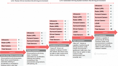
- Vehicle to Everything (V2X) Communication. V2X is an umbrella term for a vehicle’s wireless communication system, where information from sensors and other data sources is shared via high-bandwidth communication. Intelligent infrastructure solutions can use extracted trajectory road user data around intersections to predict potential collisions. This information can be used to warn connected vehicles via V2X communications. Vehicle manufacturers can leverage the solution’s analytics in combination with their on-board safety systems to reduce accident probability.
Planning for V2X Communications
In many countries, local governments view V2X technology as offering great promise to help reduce road fatalities. Much of the early V2X focus has been on communication between vehicles to exchange information that can help determine the risk of crashes so drivers can take early evasive actions, as needed. To fully realize the safety benefits of V2X, this communication needs to extend beyond vehicles to include infrastructure and pedestrians using the same roadways. In doing so, V2X can provide the critical data needed to improve traffic and protect vulnerable road users.
The future of transportation includes infrastructure interacting with vehicles through wireless technologies. For example, ITS applications can use lidar to extract trajectory road user data around intersections to predict potential collisions. This data can be used to warn connected vehicles through V2X communications. Vehicle manufacturers can leverage ITS analytics in combination with their on-board safety systems to reduce collision probability.
The world is headed to a collaborative environment between infrastructure and road users. Velodyne’s Intelligent Infrastructure Solution supports V2X communication that provides connected vehicles and autonomous vehicles with reliable multimodal traffic data. The solution converts that data into insights which vehicles can use in daily activities. Smart infrastructure integrated with connected and autonomous vehicles have the potential to deliver major improvements in roadway efficiency and safety.
Conclusion
Traffic counts are essential to optimize traffic management. Automated traffic counting is widespread on motorways today. Numerous contact loops, camera systems and radar sensors are permanently installed in order to analyze the traffic separately for heavy-duty and passenger traffic in real time.
However, often only data on the number of road users is available, depending on the type of sensor used. In addition, there are current system restrictions resulting from the use of cameras, which do not perform well in poor lighting and climate conditions, and radar, which completely misses information on vulnerable road users such as cyclists or pedestrians. Additionally, these systems can only detect collisions after they happen.
Using lidar sensors, powerful multimodal traffic analysis solutions can be created that go far beyond basic traffic counts. Lidar can provide reliable traffic data with enhanced metrics, such as real-time incident detection, warning messages, real-time accident prediction, hotspot identification and more. Lidar is an essential component to building smart, modern traffic management that can create a world where traffic accidents are rare, driving is a positive experience and carbon emissions are reduced.
Author:

Sally Frykman
Chief Marketing Officer
Velodyne Lidar
Sally Frykman is Chief Marketing Officer at Velodyne Lidar. As CMO, Sally oversees the strategic development and execution of global marketing and communications programs, including public and media relations, marketing campaigns and events, public policy and advocacy, education efforts and more. Sally is deeply committed to advancing Velodyne’s mission of creating smart technology for a world in motion to advance mobility and safety for all.
Published in Telematics Wire